
The ground between the city of Spitzplatz and the planned crossing point is obviously going to be subject to some serious large-scale maneuverings. 'Grand Tactical' is, I believe, the correct term - in my uneducated mind, anyway! So, it deserves some detailed mapping out. Below is my randonly generated terrain map. Each square is one of my 1ft x 1ft terrain tiles, which scales out at almost exactly 1 square mile. Each tile has been assigned a terrain feature in each quarter, which I then set up an Excel spreadsheet to randomly create for me. (There are free packages on the internet to do this on hexagons, but I've never come across one that works to a grid.) Anyway, here's the result. If you can't click on it to see an enlargement, would somebody please let me know how I can set that up?
 So, what have we got? As might be expected, it's a mixed bag for Aschenbach. While the crossing point is screened by a large woods (good), it's crammed in by a marsh with a farm on the far side of it (bad). Thanks to this nearby habitation, it seems sensible that there'd be come kind of crossing like a ferry, so I've dubbed the bluff on the left bank the Fahrschiff der Tauschung.
Once past this, there's a large open area called the Offen Ebene with little cover, while easy to move and fight across (good) it's pretty exposed to observation (bad). To the east of this, there's an area of marshes called the Niedringer Sumpf which should be too remote for any impact.
Next comes the really bad news. The Luftberg camp site sits at a strategic set of road junctions, within easy reach of the bridge westwards and the city to the north. By chance, there are two bands of hills to the south of this, available for easy defence. Southermost is the Windmuhle Hugel, so named because of a prominent windmill perched on it's crest, and north of that lies the larger Grosser Hugel. This hill, right on the edge of the Luftberg camp, is all but impossible to reach before the defenders awake to their peril and occupy it (bad). However, the hill runs largely NW to SE, so if the Luftbergers gain full advantage from the heights they will have to project their left flank outwards (good.)
East of the Grosser Hugel, there are quite a few areas of rough terrain. When I also randomly got two linear obstacles from the terrain generator, I knew what I'd make it - a quarry, with a partially worked rockface, which I've now dubbed the Steinbruch.
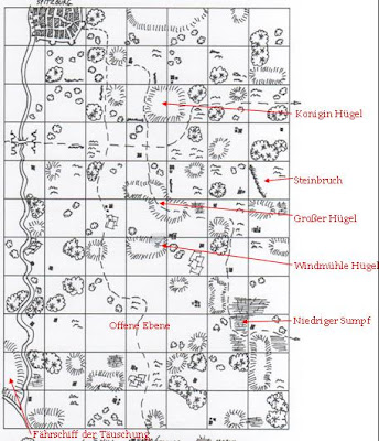
So, much in the style of Old Fritz verbally briefing his commanders on seeing a field, the general shape of the battle can be guessed at. Advancing fast from the crossing, the Aschenbach army will count the Grosser Hugel lost and instead seek to occupy the Windmuhle Hugel. From this, the - presumably - exposed Luftberg left will be assaulted obliquely by the Aschenbach right, including von Kleintrink's cavalry wing, thus cutting all it's roads of escape and crushing it's battle-line. The Aschenbach right will protect itself from envelopment by using the rough ground around the Steinbruch to disrupt any enemy movements. Von Kleintrink will take the right flank cavalry, the solid veteran Von Grenwitz will oversee the left, while Von Krumper himself will command the centre.

Which brings us to that minor technical detail of crossing the river. From reading up on the nearest contemporary battles fought over a river (I came up with the Napoleonic wars' battles of Aspern-Essling and the Berezina - utterly unscientific, but it keeps me happy!) It seems a crossing about 5-6 miles upriver is a suitably distant side-step (as Napoleon moved this far from Vienna to cross the Danube, apparently.) However, armies would cover riverlines for about double this distance (The Berezina crossing was apparently watched 12km away from Napoleon's first position on the river in 1812.) In other words, the Aschenbachers will almost certainly have to cross at Farhschiff der Tauschung under the noses of enemy light troops. How far will their luck, surprise and tactical advantages hold?
Reasoning that there is an initial 50:50 chance as to who gets the advantage, I came up with the following dice-roll chart to see when the sentries detect trouble:
1=Spotted and blocked - Luftberg gets a very early warning!
2=Spotted as soon as the raiders cross over - Luftberg gets an early warning
3=Engineers cross over - Normal Alarm Raised
4=Piles sunk in river - Normal Alarm Raised
5=Pontoons to carry Infantry are across - Luftberg gets a late warning
6=Pontoons for Artillery and horses are assembled - Luftberg gets a very late warning!
But, thanks to the Tactical cards for Surprise and Terrain, this would give Aschenbach a +1 or +2 modifier, I reckon. So, I'm rolling a dice and the result is...
Well, excuse me for drawing out the tension! Hope the above has inspired some ideas in others for depening the detail they've got in their own games!
7 comments:
Clicking on the maps (at the current time of 12:55 pm CST) doesn't enlarge them.
Jim
A terrain rich of potentialities indeed.
Very promising!
Jean-Louis
All of Beerstein is anxiously awaiting further developments!
Best regards,
Wilhelm
very nice map!
As for clicking to make it larger I found with my blog that sometimes when I download pics to add to a post they aren't clickable. The difference seems to be in the html code. Seems the html code has to start with something like less than sign plus "a href" in order for the pics to be clickable. Somtimes deleting the pic and re-downloading it fixes things for me. Other times I've copied the code from one that works and edited it. It's hard to explain (for me anyway), but probably the easiest thing to do is find an example that works and play with the code on one that doesn't.
A promising situation, and by no means clear-cut for either side. I'm looking forward to the contest of arms!
One: Batteries set up at bridge along with noise of troops getting ready to assault bridge (cover sounds of detachments marching south)?
Two: The ferry crossing has high ground on the attacker's side, batteries set up there could shell any light troops set to oppose the crossing if necessary?
:)
A
Frankfurter - good ideas. I was pondering this, and thought that the hill would conceal the army as it assembled to cross, but I'd ruled out artillery fire as causing too much noise and raising the alarm. I'd not thought of raising a racket at the bridge to cover the sounds though - very clever!
CWT
Post a Comment